Tonight, shortly after we arrived at the Super 8 motel in Abbotsford, the lights abruptly went out. I was down in the hot tub, having just gotten out of the swimming pool. Being unable to use the elevator, I slowly climbed back up the three flights of stairs to return to the lobby. Eb had been on the Internet, but later that night we were unable to get back on after the lights came back on. So this entry in the blog is being written Tuesday evening.
Alana would have enjoyed the indoor swimming pool. There was a large yellow water slide that went up one and a half stories. There were two little girls already in the pool when I got there who were 4 and 6 years old. The older girl was able to swim a little and enjoyed coming down the slide. It was a rather small pool and shallow (deepest was 4 1/2 feet) so it was difficult to swim much, but it was the first place to swim along this trip.
A transformer blew out and the whole section of town around the motel lost power. This meant that we had to adventure out and find somewhere away from the motel to eat. We had to go about 5-6 blocks before we started to see any lights on. Then we couldn't find any restaurants - it was all residential or office buildings. Finally found one, took a chance on it, and ended up with a fairly good dinner.
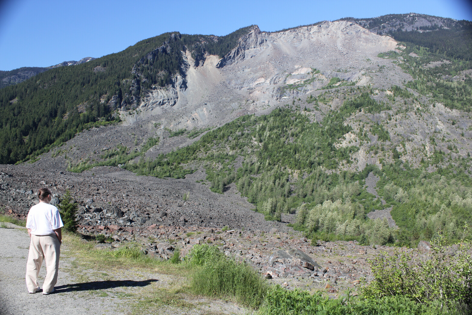
We had started that morning by leaving our motel in Princeton, BC, where we had been for three nights and followed a "scenic byway' marked in the BC Visitors Guide that was called Rivers and Ranchlands. The first section, from Princeton going north to Merritt, was the region of ranchlands and retraced where we had gone for lunch the day before. The road ran along Allison Creek and it widened out into little lakes all along the way. Along this flat valley there were numerous ranches with horses and cattle grazing and fields of wheat and grass that were being irrigated. At Merritt we turned west and followed along the Nicola River which joined the Thompson River in Spences Bridge. We wound through the mountains and narrow canyons wathing the rapids in the rivers. We had many views of snow-capped mountains. The Thompson joined with the Fraser River in Lytton to form the third largest river in Canada. We stopped for lunch at an overlook where we could view where the two rivers joined. The blue-green water of the Thompson joined with the brownish water of the Fraser and stayed along the near bank. There was a large osprey nest near this overlook. We shared the only picnic table with a family from Quebec. The older girls were quite fluent in English; the younger boy (about 7-8 years old) was either more shy and less confident of his English skills and did not share in the conversation. The family switched easily between French (in speaking among themselves) and English (in chatting with us). The road followed along the Fraser River and stopped at numerous overlooks to view the white rapids in the narrow valleys and then it would really spread out whenever it could. Hells Gate was the narrowest point of the Fraser and the river was just a mass of white. There was an aerial tramway there that you could take to the other side, which we chose not to take. We did stop there for the view and to buy some souvenirs. We continued down the Fraser valley until we got to Hope and then took a short trip east on Highway 3 (which actually leads back to Manning) to see the largest landslide reported for western Canada. The Hope Landslide occurred in January, 1965 and may have been caused by an earthquake. The first earthquake caused an avalanche to occur and several cars stopped because of that. They were then trapped by the landslide when the second earthquake happened. The landslide took off the whole side of a mountain and the debris came down and totally covered over a lake that had been there in the valley.
 |
| Ranching along the Nicola River near Merritt. There are cattle grazing among the trees. |
 |
| The Thompson River near Spences Bridge; railroads on both sides. |
 |
| Picnic lunch at Lytton, where the Thompson River joins the Fraser. See the two different waters below. |
 |
| The Hope landslide. Judy stands on 55 meters of landslide debris which came down from the side of the mountain. |
After viewing the landslide, we got on to Canada Highway 1 and headed west for Abbotsford.


No comments:
Post a Comment