We left Bozeman as early as we could, so that we would have as much time in Yellowstone National Park as possible. We drove east on I-90 and then had the choice of getting off at Highway 85 (driving two sides of a triangle) or getting off one exit earlier and taking a back road (driving only the one side of the triangle). We took the short cut which was labeled as Trail Creek Road which was a winding road through the rolling hills. In about 10 miles we were faced with a sign “Pavement ends” which actually meant it became a gravel road. Passed some cowboys herding cattle into one end of a field. Saw many very nice houses that looked relatively new mixed in with the farm / ranch houses. Eventually we came to a T intersection with no indication of which way to choose. We choose the left and it wound down the hill between fields and we could see the highway on the other side of the fields, paralleling the way we were going. Unfortunately, we were heading back north instead of south. Eventually we reached Highway 85 and later found the intersection with Trail Creek Road – obviously we should have taken the right hand turn back at the intersection. Always be suspicious of thin black lines in the road atlas drawn as perfectly straight lines.
 |
| After "Pavement ends." |
 |
| Roosevelt Arch |
Highway 85 followed the Yellowstone River to the entrance in to the national park. We passed under the Roosevelt (Teddy) Arch and came in the north entrance of the park. Teddy happened to be in the area in 1903 during construction of the arch and was asked to place the cornerstone and the arch was then named for him.
Eb and I had come to Yellowstone and the Tetons on our honeymoon 43 years ago. Both Michael and Brian have been out here on several different trips over the years. Each of us remembered different places and things to do that we wanted to return to.
Our first stop was in the Mammoth Hot Springs area. The hot springs have formed huge terraces. The terraces are stained different colors (white, yellow, pink, orange) because of the microorganisms in the water which are determined by the temperature of the spring. Steam is constantly rising off most of the water.
 |
| Some of the colorful deposits at Mammoth Hot Springs. |
As you are driving through Yellowstone there are large geyser basins and just individual hot springs / geysers / fumaroles just randomly along the way. It must have been astounding for the first explorers coming through the area who had no idea of what was in this area. The park posts signs “Dangerous Ground”. Thin crusts of mineral deposits are formed but, if you try to walk across this ground, this crust can crack and you might land in some very hot water.
 |
| One of many small thermal area along the road through Yellowstone. |
Our second stop was an attempt to view the Upper and Lower Yellowstone Falls. We had to drive on the loop around to the Canyon Village. We followed the signs to the parking lot labeled “Upper Falls”. It turned out it was for the “brink” of the Upper Falls and not a view of the entire falls. It still was very impressive to see the mass of water roar over the edge of the cliff and then from another view spot see how the spray from the water would shoot up 10 – 20 feet above the plunge pool. We could see two different overlooks for the Upper Falls (even with people there), but couldn’t find on the map that we had how to get to them.
 |
| Looking over the brink of the Upper Falls of the Yellowstone. |
As we were driving around we saw the signs of the blackened trees from the earlier Yellowstone fires. On the trip in 1993 (with Brian) we had seen the blackened trees fresh from the big West Yellowstone Fire from the previous year. Now there are young trees growing up amongst the downed or blackened trees. The signs along the road indicated that this was natural reforestation, the natural cycle of pine cones opening due to the heat of the fires causing the cones to drop out their seeds.
 |
| Old Faithful geyser, height of eruption and afterwards |
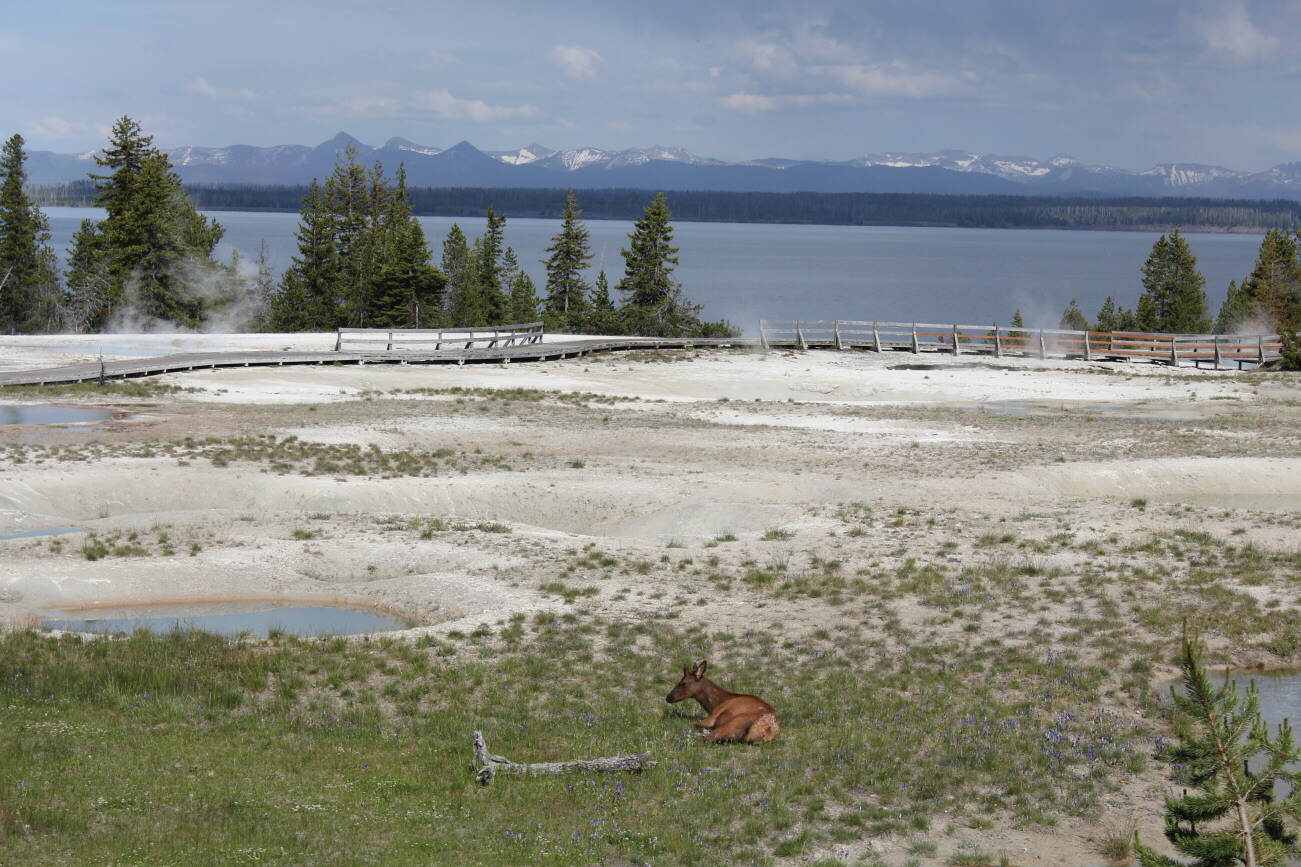
Our last stop in Yellowstone was at the West Thumb Geyser Basin which is at the south end of Yellowstone Lake. I have always remembered enjoying watching the mud pots as they “plopped” with each gas bubble rising up through the thick mud. In the basin there were a variety of different colored hot springs (due to the organisms and temperature) and some fumaroles (steam coming out of holes in the ground). There also was an elk sleeping in the grass in the middle of the basin.
 |
| Some pools with elk at West Thumb; Yellowstone Lake in background. |
We did not see any bears in Yellowstone. We did see bison in several places, the elk, and a coyote running across the road.
 |
| One of the buffalo we saw, this one sleeping by the side of the road |
In order to see Yellowstone, you need many days, instead of the one day that we had. It is huge area and you need lots of time just to drive from one place to the other. There are many different geyser basins to visit, hikes to go on, and visitor centers and museums to go to in order to get more information.

We left Yellowstone and drove south to The Grand Teton National Park. On this drive we crossed the Continental Divide three times. Going over the passes we had snow right along side the road and back in to the woods. All day we had been seeing snow-covered peaks and this drive south gave us some spectacular views of the mountains, finally climaxing with our view of the Tetons which have always been breath-taking to see, but this year they are more snow-covered than ever.
On the wall at home we have a picture of Michael (at age 4) and one of Brian (at age 14) both in the same place – playing in the chilly waters of Jackson Lake (which was formed by damming up the Snake River to provide irrigation) with a point of trees and the Tetons in the background. We found the same place, in the picnic area at Coulter Bay, and got a picture of Eb and I in the same location (but not out in the water).
 |
| Coulter Bay, 1976 with Michael, 1993 with Brian, and us in 2011 |
We are staying in a Hostel in Teton Village which is at the base of the Jackson Hole Ski area. Michael, when you were just two years old, you were camped up on the ledges on Rendezvous Peak just above Teton Village. We were supposed to have met Doug and Hazel up on the mountain but ended up there by ourselves. That night there was a terrific thunderstorm with gusting winds and lots of lightning. Daddy and I stayed awake while Michael slept through the storm. Daddy had to keep putting large rocks on the tent stakes to keep them from pulling out. The next day we hiked up to the peak so we could ride the tram back down the mountain. The tourists coming up for the view (in their shorts and t-shirts) were shivering and complaining and went right back down. We were dressed in boots, gloves, and warm jackets and enjoyed sitting up at the building on the summit and eating a lunch / snacks before going down. Brian, when you were here at 14, we rode the tram up the mountain and hiked over to a snowfield which was about 1 ½ miles away. You enjoyed sliding and playing on the snowfield in August. It looks like the snow is completely covering the top of the tramway. We are going to ride the aerial tramway up the mountain and enjoy a picnic lunch up on the top. But, we are planning on wearing lots of layers because I am sure that it will be cold and windy up on top.
Here in Teton Village there are many large resort hotels and condominiums along with many elegant restaurants (went to the Mangy Moose for an excellent dinner – I had steak and Daddy had trout). The rooms in the Hostel have just a bare minimum but are nice and clean. There is a king size bed which dominates the space in the room. Daddy is already asleep on the bed, so I better close this off. There is no Internet (and we are going to be here for tomorrow night as well) so it may be another two days before this gets posted. But, at least, I got it written while I still remembered what we did today.


 We left Yellowstone and drove south to The Grand Teton National Park. On this drive we crossed the Continental Divide three times. Going over the passes we had snow right along side the road and back in to the woods. All day we had been seeing snow-covered peaks and this drive south gave us some spectacular views of the mountains, finally climaxing with our view of the Tetons which have always been breath-taking to see, but this year they are more snow-covered than ever.


No comments:
Post a Comment